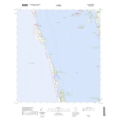
2024 Map of Captiva
USGS Topo · Published 2024About this map
North Captiva Island and its string of barrier keys define this coastal landscape where the Gulf of Mexico meets Pine Island Sound. The map documents a fragile environment of shoals and passes, including Redfish Pass and Captiva Pass, which separate the primary landmasses. On Captiva Island, the settlement of Captiva is detailed alongside the Captiva Historic Cem, providing a focal point for local history and genealogy.
Find a feature on this map
54 named features on this map. Tap any name to fly to it.
Don’t see what you’re looking for? This feature index may not catch every label — zoom into the map to look around manually.
Map Details
Editions of this 2024 Captiva Map
This is the sole edition of this map. No revisions or reprints were ever made.
Other maps of this area

1956 · Tampa
USGS Topo · 1:250,000

1956 · Charlotte Harbor
USGS Topo · 1:250,000

1958 · Matlacha
USGS Topo · 1:24,000

1958 · Captiva
USGS Topo · 1:24,000

1958 · Port Boca Grande
USGS Topo · 1:24,000

1958 · Sanibel
USGS Topo · 1:24,000

1958 · Pine Island Center
USGS Topo · 1:24,000

1958 · Bokeelia
USGS Topo · 1:24,000
1958 · Wulfert
USGS Topo · 1:24,000

1959 · Tampa
USGS Topo · 1:250,000