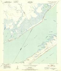
1943 Map of Carancahua Lake
USGS Topo · Published 1952About this map
Galveston Island and the coastal marshes of the West Bay are depicted here during the early 1940s, highlighting a landscape defined by the Intracoastal Waterway. The map reveals the intricate transition from the open waters of the Gulf of Mexico to the protected wetlands and lagoons, including Halls Lake and Carancahua Lake. The boundary between Galveston and Brazoria counties bisects the bay, winding through the channel of Halls Bayou. Evidence of early coastal activity appears in the form of several scattered windmills and the Boathouse Ruins on the inland side of the barrier island. Notable landforms like Rattlesnake Mound rise above the marshy terrain, while the shoreline is broken by features such as Bird Island Cove and Snake Island. This survey captures the coastline as it existed prior to mid-century development, focusing on the natural geography of the Texas Gulf Coast.
Find a feature on this map
28 named features on this map. Tap any name to fly to it.
Don’t see what you’re looking for? This feature index may not catch every label — zoom into the map to look around manually.
Map Details
Editions of this 1943 Carancahua Lake Map
This is the sole edition of this map. No revisions or reprints were ever made.
Other maps of this area

1929 · Karankawa Lake
USGS Topo · 1:24,000

1929 · Hitchcock
USGS Topo · 1:24,000

1929 · Virginia Point
USGS Topo · 1:24,000

1931 · Lake Como
USGS Topo · 1:24,000

1932 · Hitchcock
USGS Topo · 1:31,680

1932 · Mustang Bayou
USGS Topo · 1:31,680

1932 · Virginia Point
USGS Topo · 1:31,680

1933 · Karankawa Lake
USGS Topo · 1:31,680

1933 · San Luis Pass
USGS Topo · 1:31,680
1933 · Lake Como
USGS Topo · 1:31,680