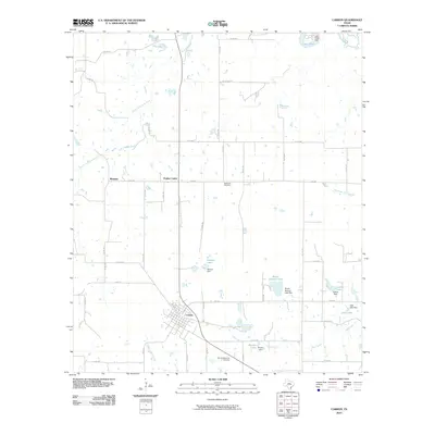
2010 Map of Carbon
USGS Topo · Published 2010About this map
The town of Carbon serves as the central hub of this Eastland County landscape, where the street grid transitions into a network of farm-to-market and county roads. The terrain is defined by a complex hydrographic system, with the South Fork Leon River and the Leon River cutting through the northern reaches. Small-scale water management is evident throughout the area, characterized by Numerous earthen works such as Hanson Dam and Bryant Dam, which have created localized reservoirs like Hanson Lake and Bryant Lake.
Find a feature on this map
57 named features on this map. Tap any name to fly to it.
Don’t see what you’re looking for? This feature index may not catch every label — zoom into the map to look around manually.
Map Details
Editions of this 2010 Carbon Map
This is the sole edition of this map. No revisions or reprints were ever made.
Other maps of this area

1894 · Eastland
USGS Topo · 1:125,000

1954 · Abilene
USGS Topo · 1:250,000

1958 · Abilene
USGS Topo · 1:250,000

1966 · Cisco North
USGS Topo · 1:24,000

1966 · Kokomo
USGS Topo · 1:24,000

1966 · Carbon
USGS Topo · 1:24,000

1966 · Eastland
USGS Topo · 1:24,000

1966 · Cisco South
USGS Topo · 1:24,000

1966 · Ranger
USGS Topo · 1:24,000
1968 · Gorman
USGS Topo · 1:24,000