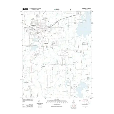
2012 Map of Carbondale
USGS Topo · Published 2012About this map
Southern Illinois University anchors this part of southern Illinois, its campus featuring Campus Lake and the University School. The city of Carbondale is shown in detail, including its residential expansion and the Marberry Arboretum near Evergreen Terrace. To the south, the landscape transitions into a network of creeks and small settlements like Boskydell, where the Boskydell Cem and Snider Hill Cem serve as markers for local family histories. The region is defined by its water resources, with the extensive Crab Orchard Lake in the northeast and Little Grassy Lake at the southern edge, which supports the Little Grassy Fish Hatchery. This terrain reflects the area's development as an educational hub and a gateway to the diverse recreation areas of the Shawnee Hills region.
Find a feature on this map
93 named features on this map. Tap any name to fly to it.
Don’t see what you’re looking for? This feature index may not catch every label — zoom into the map to look around manually.
Map Details
Editions of this 2012 Carbondale Map
This is the sole edition of this map. No revisions or reprints were ever made.
Other maps of this area

1910 · Herrin
USGS Topo · 1:62,500

1910 · Murphysboro
USGS Topo · 1:62,500

1922 · Carbondale
USGS Topo · 1:62,500

1924 · Alto Pass
USGS Topo · 1:62,500

1936 · Herrin
USGS Topo · 1:62,500

1938 · Murphysboro
USGS Topo · 1:62,500

1941 · Carbondale
USGS Topo · 1:62,500

1947 · Alto Pass
USGS Topo · 1:62,500
1947 · Cobden
USGS Topo · 1:24,000
1948 · Cobden
USGS Topo · 1:24,000