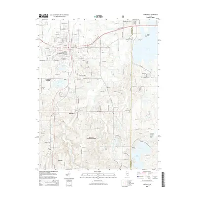
2015 Map of Carbondale
USGS Topo · Published 2015About this map
Southern Illinois University Carbondale sits at the heart of this Southern Illinois landscape, where the urban grid of Carbondale transitions into the hills and drainages of the Shawnee National Forest. The Illinois Central Railroad serves as a primary north-south spine, passing through the smaller settlements of Boskydell and Makanda. This corridor is defined by its complex hydrology, with Crab Orchard Creek and its many tributaries, such as Drury Creek and Sycamore Creek, carving through the terrain toward the expansive Crab Orchard Lake in the northeast and Little Grassy Lake in the southeast.
Find a feature on this map
105 named features on this map. Tap any name to fly to it.
Don’t see what you’re looking for? This feature index may not catch every label — zoom into the map to look around manually.
Map Details
Editions of this 2015 Carbondale Map
This is the sole edition of this map. No revisions or reprints were ever made.
Other maps of this area

1910 · Herrin
USGS Topo · 1:62,500

1910 · Murphysboro
USGS Topo · 1:62,500

1922 · Carbondale
USGS Topo · 1:62,500

1924 · Alto Pass
USGS Topo · 1:62,500

1936 · Herrin
USGS Topo · 1:62,500

1938 · Murphysboro
USGS Topo · 1:62,500

1941 · Carbondale
USGS Topo · 1:62,500

1947 · Alto Pass
USGS Topo · 1:62,500
1947 · Cobden
USGS Topo · 1:24,000
1948 · Cobden
USGS Topo · 1:24,000