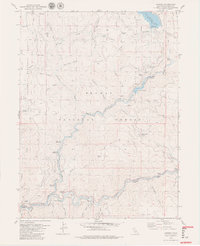
1979 Map of Caribou
USGS Topo · Published 1979About this map
Rich Bar and Belden anchor the riverfront in this 1970s survey of the Feather River canyon. The landscape is defined by the heavy infrastructure of hydroelectric power and mining, with the North Fork Feather River and its East Branch meeting near a series of tunnels and gaging stations. The Pacific Western railroad line tracks the river's curve, passing through Tunnel 23, Tunnel 24, and Tunnel 25. This mapping also reveals the legacy of gold mining in the region, noting several river bars such as Indian Bar, Pea Soup Bar, and Missouri Bar.
Find a feature on this map
63 named features on this map. Tap any name to fly to it.
Don’t see what you’re looking for? This feature index may not catch every label — zoom into the map to look around manually.
Map Details
Editions of this 1979 Caribou Map
4 editions found
Other maps of this area

1886 · Lassen Peak
USGS Topo · 1:250,000

1888 · Bidwell Bar
USGS Topo · 1:125,000

1891 · Bidwell Bar
USGS Topo · 1:125,000

1892 · Lassen Peak
USGS Topo · 1:250,000

1893 · Bidwell Bar
USGS Topo · 1:125,000

1894 · Lassen Peak
USGS Topo · 1:250,000

1895 · Bidwell Bar
USGS Topo · 1:125,000

1897 · Bidwell Bar
USGS Topo · 1:125,000

1950 · Bucks Lake
USGS Topo · 1:62,500

1955 · Almanor
USGS Topo · 1:62,500