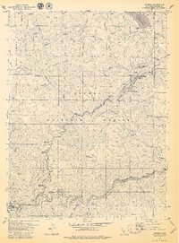
1979 Map of Caribou
USGS Topo · Published 1979About this map
Gold-era mining settlements and hydroelectric infrastructure dominate this late 1970s landscape within the Plumas National Forest. The map documents the intricate river-and-rail corridor where the Western Pacific railroad tracks navigate the winding East Branch North Fork Feather River. Along the water, historic bars like Rich Bar, Indian Bar, and Pea Soup Bar stand as markers of the region's mining heritage, while the Butt Valley Reservoir Spillway Elevation 4142 and associated Aqueduct systems highlight the mid-century industrialization of the Feather River canyon.
Find a feature on this map
72 named features on this map. Tap any name to fly to it.
Don’t see what you’re looking for? This feature index may not catch every label — zoom into the map to look around manually.
Map Details
Editions of this 1979 Caribou Map
4 editions found
Other maps of this area

1886 · Lassen Peak
USGS Topo · 1:250,000

1888 · Bidwell Bar
USGS Topo · 1:125,000

1891 · Bidwell Bar
USGS Topo · 1:125,000

1892 · Lassen Peak
USGS Topo · 1:250,000

1893 · Bidwell Bar
USGS Topo · 1:125,000

1894 · Lassen Peak
USGS Topo · 1:250,000

1895 · Bidwell Bar
USGS Topo · 1:125,000

1897 · Bidwell Bar
USGS Topo · 1:125,000

1950 · Bucks Lake
USGS Topo · 1:62,500

1955 · Almanor
USGS Topo · 1:62,500