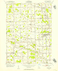
1952 Map of Carleton
USGS Topo · Published 1954About this map
Agricultural lands at the border of Wayne and Monroe Counties define this mid-century landscape, where a dense network of drainage canals like Carroll Drain and Duff Drain supported the local farming economy. The village of Carleton serves as the primary hub, situated at a significant rail junction. Transport is central to the area's layout, with the Detroit Toledo and Ironon, Chesapeake and Ohio, and Pennsylvania railroads bisecting the terrain to connect these rural townships with larger industrial centers.
Find a feature on this map
83 named features on this map. Tap any name to fly to it.
Don’t see what you’re looking for? This feature index may not catch every label — zoom into the map to look around manually.
Map Details
Editions of this 1952 Carleton Map
2 editions found
Other maps of this area

1902 · Ypsilanti
USGS Topo · 1:62,500

1904 · Ann Arbor
USGS Topo · 1:125,000

1906 · Ypsilanti
USGS Topo · 1:62,500

1906 · Romulus
USGS Topo · 1:62,500

1908 · Ann Arbor
USGS Topo · 1:125,000

1912 · Monroe
USGS Topo · 1:62,500

1912 · Dundee
USGS Topo · 1:62,500

1914 · Monroe
USGS Topo · 1:62,500

1926 · Dundee
USGS Topo · 1:62,500

1927 · Monroe
USGS Topo · 1:31,680
Featured Places
- Frenchtown Charter Township, MI
- Huron Charter Township, MI
- Sumpter Township, MI
- Ash Township, MI
- Raisinville Township, MI