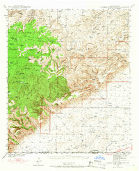
1940 Map of Carlsbad Caverns West
USGS Topo · Published 1966About this map
Queen Cem and the small settlement of Queen anchor the high country in this 1940 survey of the Guadalupe Mountains. The landscape is defined by a complex network of deep drainages including Slaughter Canyon, Dark Canyon, and Lechuguilla Canyon, which cut through the limestone toward the Black River. This period of land use is heavily marked by scattered ranching outposts such as Montgomery Ranch, Schermer Ranch, and McCollum Ranch, each situated near critical water sources like Pats Lake or Sitting Bull Spring. The map documents the early recreational and administrative footprint of the region, featuring the Sitting Bull Recreational Area at Sitting Bull Falls and the Carson Seep Ranger Sta, providing a detailed look at the rural infrastructure of the New Mexico-Texas borderlands before later development.
Find a feature on this map
83 named features on this map. Tap any name to fly to it.
Don’t see what you’re looking for? This feature index may not catch every label — zoom into the map to look around manually.
Map Details
Editions of this 1940 Carlsbad Caverns West Map
5 editions found
Other maps of this area

1933 · Guadalupe Peak
USGS Topo · 1:48,000

1935 · El Paso Gap
USGS Topo · 1:62,500

1936 · El Paso Gap
USGS Topo · 1:48,000

1940 · El Paso Gap
USGS Topo · 1:62,500

1940 · Guadalupe Peak
USGS Topo · 1:62,500

1940 · Bandanna Point
USGS Topo · 1:62,500

1940 · Carlsbad Caverns West
USGS Topo · 1:62,500

1943 · Carlsbad Caverns West
USGS Topo · 1:62,500

1943 · Bandanna Point
USGS Topo · 1:62,500

1943 · Texas Hill
USGS Topo · 1:62,500