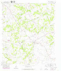
1956 Map of Carlton
USGS Topo · Published 1979About this map
Carlton serves as the central hub of this Central Texas landscape, where the borders of Erath, Hamilton, and Comanche counties converge. The settlement is anchored by a local High Sch and an adjacent Cem, reflecting a small-town social structure typical of the mid-20th century. A defunct transportation network is evident in the Old Railroad Grade that cuts through the territory, a relic of earlier rail connectivity that once linked these rural communities to larger Texas markets.
Find a feature on this map
19 named features on this map. Tap any name to fly to it.
Don’t see what you’re looking for? This feature index may not catch every label — zoom into the map to look around manually.
Map Details
Editions of this 1956 Carlton Map
3 editions found
Other maps of this area

1888 · Hamilton
USGS Topo · 1:125,000

1890 · Stephenville
USGS Topo · 1:125,000

1894 · Hamilton
USGS Topo · 1:125,000

1920 · Stephenville
USGS Topo · 1:125,000

1954 · Brownwood
USGS Topo · 1:250,000

1954 · Abilene
USGS Topo · 1:250,000

1956 · Gustine
USGS Topo · 1:62,500

1956 · Gentrys Mill
USGS Topo · 1:24,000

1956 · Hico
USGS Topo · 1:62,500
1956 · Eidson Lake
USGS Topo · 1:24,000