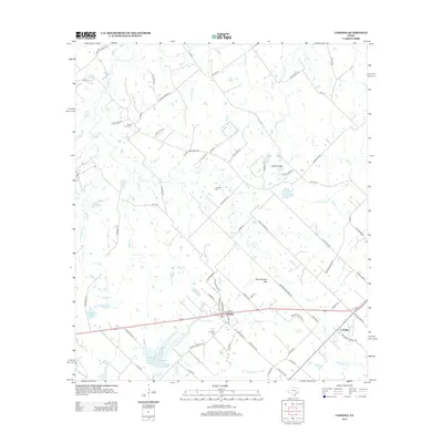
2013 Map of Carmine
USGS Topo · Published 2013About this map
Carmine serves as the primary hub of this landscape, situated along a network of ranch-to-market roads and local lanes that define the agricultural character of Fayette County. The map details a transition from the rolling terrain near Homeymeyer Mtn and the White Bluffs to the various drainages that feed the local watershed, including Fourmile Cr and Cedar Cr. Genealogists will find significant value in the documentation of local burial sites like the White Union Cem, Hartstack Cem, and Carmine Cem, which are scattered among family-named roads such as Lentz Meier Ln and Koether Rd. To the southwest, the Soil Conservation Service Site 7 Reservoir illustrates the modern infrastructure managing the many creeks that crisscross the prairie, including Alligator Cr and Buck Cr. The small community of La Bahia sits in the southeast corner, marking a site deeply tied to early regional travel routes.
Find a feature on this map
84 named features on this map. Tap any name to fly to it.
Don’t see what you’re looking for? This feature index may not catch every label — zoom into the map to look around manually.
Map Details
Editions of this 2013 Carmine Map
This is the sole edition of this map. No revisions or reprints were ever made.
Other maps of this area

1919 · Giddings
USGS Topo · 1:62,500

1919 · Dime Box
USGS Topo · 1:62,500

1954 · Austin
USGS Topo · 1:250,000

1956 · Somerville
USGS Topo · 1:62,500

1958 · Ledbetter
USGS Topo · 1:24,000

1958 · Greenvine
USGS Topo · 1:24,000
1958 · Nechanitz
USGS Topo · 1:24,000

1958 · Carmine
USGS Topo · 1:24,000

1958 · Burton
USGS Topo · 1:24,000
1958 · Round Top
USGS Topo · 1:24,000