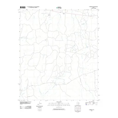
2010 Map of Carmona
USGS Topo · Published 2010About this map
The settlement of Carmona anchors this part of East Texas, where the landscape is defined by a dense network of watercourses branching through the piney woods. Water drainage patterns are particularly intricate here, with White Oak Creek, Salt Creek, and Long Tom Creek carving distinct paths across the quadrangle. This 2010 USGS survey captures the rural character of Polk County, showing how local transit routes like Towns Cemetery Rd and Old Berring Rd connect isolated homesteads and timberlands. Genealogists will find the Carmona Cemetery as a primary point of interest, situated just east of the main settlement area. The map illustrates a quiet, hydraulic landscape where small tributaries such as Pump Branch and Bridge Creek feed into larger creek systems, reflecting the area's geography before significant modern urbanization.
Find a feature on this map
22 named features on this map. Tap any name to fly to it.
Don’t see what you’re looking for? This feature index may not catch every label — zoom into the map to look around manually.
Map Details
Editions of this 2010 Carmona Map
This is the sole edition of this map. No revisions or reprints were ever made.
Other maps of this area

1953 · Palestine
USGS Topo · 1:250,000

1954 · Beaumont
USGS Topo · 1:250,000

1955 · New Willard
USGS Topo · 1:62,500

1957 · Beaumont
USGS Topo · 1:250,000

1957 · Palestine
USGS Topo · 1:250,000

1960 · Colita
USGS Topo · 1:24,000

1961 · Onalaska
USGS Topo · 1:24,000

1963 · Groveton East
USGS Topo · 1:24,000
1963 · Trevat
USGS Topo · 1:24,000
1963 · Wakefield
USGS Topo · 1:24,000