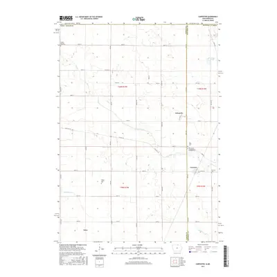
2015 Map of Carpenter
USGS Topo · Published 2015About this map
The small settlements of Carpenter and Meltonville anchor this northern Iowa landscape along the border of Worth and Mitchell counties. This rural expanse is defined by the winding course of Deer Creek, which flows southeast toward the town of Carpenter. The map reveals a high concentration of burial sites and family heritage markers, such as the Birdsal Family Plot and the combined NE Lutheran Congregational Carpenter Cem. In the northwest, the London and Deer Creek Cem sits near the creek's upper reaches, while Newburg Cem lies on the eastern edge of the survey. The terrain is structured by a rigorous grid of county roads, including State Hwy 105 and Zinnia Ave, connecting agricultural plots and small water features like Markhams Pond and Ditch Number 11. Further south, the hamlet of Bolan appears near the banks of Willow Cr.
Find a feature on this map
43 named features on this map. Tap any name to fly to it.
Don’t see what you’re looking for? This feature index may not catch every label — zoom into the map to look around manually.
Map Details
Editions of this 2015 Carpenter Map
This is the sole edition of this map. No revisions or reprints were ever made.
Other maps of this area

1954 · Hayward
USGS Topo · 1:62,500

1954 · Austin
USGS Topo · 1:62,500

1954 · Mason City
USGS Topo · 1:250,000

1957 · Mason City
USGS Topo · 1:250,000

1958 · Mason City
USGS Topo · 1:250,000

1972 · St. Ansgar
USGS Topo · 1:24,000

1972 · Osage SW
USGS Topo · 1:24,000

1972 · Manly
USGS Topo · 1:24,000

1972 · Northwood
USGS Topo · 1:24,000
1972 · Grafton
USGS Topo · 1:24,000