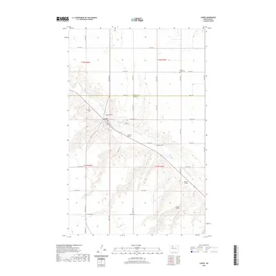
2020 Map of Carpio
USGS Topo · Published 2020About this map
The Des Lacs River valley defines the landscape of Ward County, cutting a winding path through the prairie where the settlement of Carpio is established. This 2020 topographic study shows the community situated at the confluence of the river and Flaten Coulee, a geography that has historically shaped the town's development and transportation corridors like CO Hwy 6. The surrounding plateau is deeply etched by a series of significant drainage features including Johnson Coulee, Oleaas Coulee, and Hanson Coulee, reflecting the erosional power of water in this northern plains environment.
Find a feature on this map
27 named features on this map. Tap any name to fly to it.
Don’t see what you’re looking for? This feature index may not catch every label — zoom into the map to look around manually.
Map Details
Editions of this 2020 Carpio Map
This is the sole edition of this map. No revisions or reprints were ever made.
Other maps of this area

1947 · Tolley
USGS Topo · 1:62,500

1949 · Tolley SE
USGS Topo · 1:24,000

1949 · Hartland
USGS Topo · 1:24,000

1949 · Carpio NE
USGS Topo · 1:24,000

1949 · Carpio
USGS Topo · 1:24,000

1949 · Grano SW
USGS Topo · 1:24,000

1949 · Grano
USGS Topo · 1:24,000

1950 · Tolley
USGS Topo · 1:62,500

1950 · Des Lacs
USGS Topo · 1:24,000
1951 · Grano
USGS Topo · 1:62,500