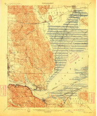
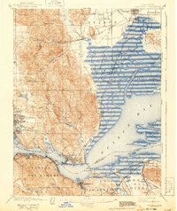
1901 Map of Carquinez
USGS Topo · Published 1911About this map
Benicia and Vallejo anchor this 1901 survey of the maritime gateway where the Carquinez Strait meets Suisun Bay. The landscape is dominated by the strategic intersection of deep-water transit and transcontinental rail, notably the Southern Pacific R. R. winding through Jameson Canyon Creek and along the shoreline. A significant military presence is evident at the U. S. Arsenal near Army Pt., while the industrial waterfronts of Martinez, Crockett, and Port Costa illustrate the era's heavy reliance on wharf-side commerce. To the north, the intricate wetlands of Grizzly Island and Joice Island are etched with tidal channels like Montezuma Slough, appearing as they did before modern reclamation. Inland, the topography rises sharply at Sulphur Springs Mt., separating the marshes from the burgeoning agricultural settlements of Fairfield and Cordelia.
Find a feature on this map
88 named features on this map. Tap any name to fly to it.
Don’t see what you’re looking for? This feature index may not catch every label — zoom into the map to look around manually.
Map Details
Editions of this 1901 Carquinez Map
6 editions found
Other maps of this area

1895 · San Francisco
USGS Topo · 1:62,500

1896 · Carquinez Strait
USGS Topo · 1:62,500

1896 · Mt. Diablo
USGS Topo · 1:62,500

1897 · Concord
USGS Topo · 1:62,500

1898 · Karquines
USGS Topo · 1:62,500

1898 · Mt. Diablo
USGS Topo · 1:62,500

1899 · San Francisco
USGS Topo · 1:62,500

1901 · Karquines
USGS Topo · 1:62,500

1902 · Napa
USGS Topo · 1:125,000

1907 · Antioch
USGS Topo · 1:62,500