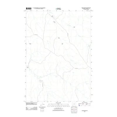
2012 Map of Carr Draw
USGS Topo · Published 2012About this map
Barber Creek Oil Field defines the industrial footprint of this Campbell County landscape, where energy extraction meets the intricate drainage systems of the High Plains. The terrain is characterized by a series of significant erosional features including Carr Draw, Antelope Draw, and Bull Draw, which channel seasonal runoff toward larger systems like Fortification Cr. These watercourses dictate the path of local infrastructure, such as Barber Creek Rd and Maycock Rd. In the southern portion of the map, the headwaters of Barber Cr and the S Prong Barber Cr carve through the earth, illustrating the relationship between the regional hydrology and the active petroleum development that has shaped this portion of Wyoming's energy corridor.
Find a feature on this map
14 named features on this map. Tap any name to fly to it.
Don’t see what you’re looking for? This feature index may not catch every label — zoom into the map to look around manually.
Map Details
Editions of this 2012 Carr Draw Map
This is the sole edition of this map. No revisions or reprints were ever made.
Other maps of this area

1954 · Gillette
USGS Topo · 1:250,000

1955 · Sheridan
USGS Topo · 1:250,000

1955 · Gillette
USGS Topo · 1:250,000

1958 · Gillette
USGS Topo · 1:250,000

1958 · Sheridan
USGS Topo · 1:250,000

1962 · Gillette
USGS Topo · 1:250,000

1962 · Sheridan
USGS Topo · 1:250,000
1971 · Scott Dam
USGS Topo · 1:24,000
1971 · Morgan Draw
USGS Topo · 1:24,000
1972 · Carr Draw
USGS Topo · 1:24,000