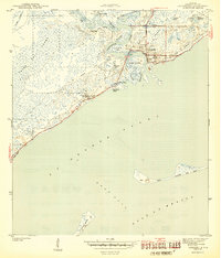
1944 Map of Carrabelle
USGS Topo · Published 1944About this map
The Carrabelle River system dominates this mid-century coastal survey, converging where the New River and Crooked River meet the salt waters of St George Sound. The town of Carrabelle is the focal point of the region's industry and transport, served by the Seaboard railroad and protected by the Carrabelle Lighthouse to the southwest. The geography is defined by a complex network of bayous and ponds, including Poston Bayou and Lake Morality, which border the massive expanse of Tates Hell Swamp. This terrain necessitated specialized landings such as Strip Landing for access. Local genealogy and land use are preserved in names like Yent Place, Warrens Bluff, and the settlement of Davis, while the barrier islands of Dog Island and St George Island frame the East Pass entrance to the gulf.
Find a feature on this map
32 named features on this map. Tap any name to fly to it.
Don’t see what you’re looking for? This feature index may not catch every label — zoom into the map to look around manually.
Map Details
Editions of this 1944 Carrabelle Map
4 editions found
Other maps of this area

1943 · Dog Island
USGS Topo · 1:31,680

1943 · Carrabelle
USGS Topo · 1:24,000

1944 · Pickett Bay
USGS Topo · 1:31,680

1944 · Carrabelle
USGS Topo · 1:31,680

1944 · Green Point
USGS Topo · 1:31,680

1944 · Sugar Hill
USGS Topo · 1:31,680

1945 · Tates Hell Swamp
USGS Topo · 1:31,680

1945 · Mc Intyre
USGS Topo · 1:31,680

1945 · Sugar Hill
USGS Topo · 1:31,680

1945 · Pickett Bay
USGS Topo · 1:31,680