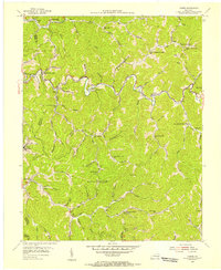
1954 Map of Carrie
USGS Topo · Published 1956About this map
Troublesome Creek and its many winding tributaries define this mid-century landscape on the border of Perry and Knott Counties. The area is characterized by a dense network of hollows and ridges, where small communities like Emmalena, Carrie, and Fisty are positioned along the narrow valley floors. The distribution of civic structures during the 1950s shows a decentralized community life, with numerous rural schools such as the Ode Everage Sch and Lower Montgomery Creek Sch serving isolated populations. While agriculture and local gas wells are present, the early presence of a Strip Mine near Tina signals the region's industrial ties to the coal industry. Notable landmarks like the Maggie Memorial Ch and the high point at Ash Bee Tree Gap provide essential orientation for those tracing family history or the evolution of Kentucky's mountain settlements.
Find a feature on this map
83 named features on this map. Tap any name to fly to it.
Don’t see what you’re looking for? This feature index may not catch every label — zoom into the map to look around manually.
Map Details
Editions of this 1954 Carrie Map
4 editions found
Other maps of this area

1890 · Whitesburg
USGS Topo · 1:125,000

1891 · Hazard
USGS Topo · 1:125,000

1892 · Whitesburg
USGS Topo · 1:125,000

1912 · Hindman
USGS Topo · 1:48,000

1913 · Oven Fork
USGS Topo · 1:48,000

1914 · Troublesome
USGS Topo · 1:62,500

1915 · Hindman
USGS Topo · 1:62,500

1915 · Whitesburg
USGS Topo · 1:62,500

1916 · Cornettsville
USGS Topo · 1:62,500

1954 · Noble
USGS Topo · 1:24,000