Loading...
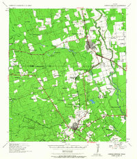
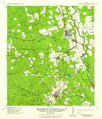
Loading map...1939 Map of Carrizo Springs
USGS Topo · Published 1963About this map
Crystal City serves as the primary hub of this South Texas landscape, defined by an intricate network of water and early 20th-century agriculture. The Nueces River winds through the eastern portion of the sheet, feeding into Espantosa Lake and creating a fertile corridor for numerous private properties. Numerous family-named homesteads and agricultural operations like McKnight Ranch, Giesler Farm, and the Wagner Dairy highlight the area's rural development.
Find a feature on this map
95 named features on this map. Tap any name to fly to it.
Don’t see what you’re looking for? This feature index may not catch every label — zoom into the map to look around manually.
Map Details
Date Portrayed1939
Date Published1963
PublisherU.S. Geological Survey
Map TypeTopographic
Scale1:62,500
Physical Dimensions18.1 x 20.9 inches
Editions of this 1939 Carrizo Springs Map
2 editions found
Historical Maps of Crystal City Through Time
1 maps found
Featured Locations
- Byrd, TX
- Carrizo Springs, TX
- Amaya Colonia, TX
- Crystal City, TX
- La Hacienda Estates Number 2 Colonia, TX
Source Details
SourceU.S. Geological Survey
CopyrightPublic Domain