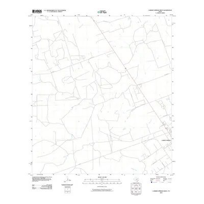
2010 Map of Carrizo Springs West
USGS Topo · Published 2010About this map
Carrizo Springs anchors the southeastern corner of this South Texas survey, where the town's expanding street grid meets the ranchlands and dry creek beds of Dimmit County. The landscape is defined by the ephemeral drainages of Peña Creek and Rocky Creek, which snake across a terrain partitioned into large geometric parcels and accessed by a network of ranch-to-market roads. These thoroughfares, including FM 2644 and Ranch Rd 191, indicate the regional reliance on transit between scattered agricultural outposts and the municipal center. The transition from the urban density of State Loop 517 to the open tracts along Escondid Rd and Williams Rd illustrates the modern development pattern of this Brush Country region, maintaining its character as a hub for both energy and cattle interests.
Find a feature on this map
16 named features on this map. Tap any name to fly to it.
Don’t see what you’re looking for? This feature index may not catch every label — zoom into the map to look around manually.
Map Details
Editions of this 2010 Carrizo Springs West Map
This is the sole edition of this map. No revisions or reprints were ever made.
Other maps of this area

1929 · Cotulla
USGS Topo · 1:125,000

1939 · Carrizo Springs
USGS Topo · 1:62,500

1940 · Asherton
USGS Topo · 1:62,500

1940 · Cometa
USGS Topo · 1:62,500

1941 · Botella Creek
USGS Topo · 1:62,500

1953 · Crystal City
USGS Topo · 1:250,000

1955 · Crystal City
USGS Topo · 1:250,000

1957 · Botella Creek
USGS Topo · 1:62,500

1958 · Eagle Pass
USGS Topo · 1:250,000

1961 · Crystal City
USGS Topo · 1:250,000