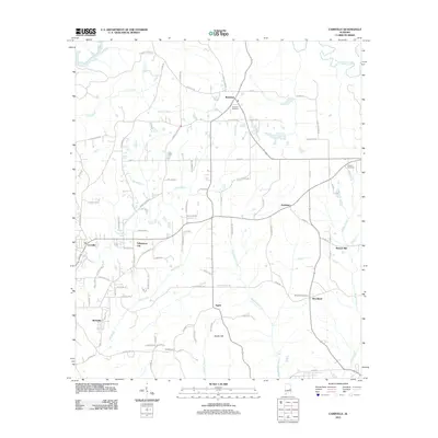
2011 Map of Carrville
USGS Topo · Published 2011About this map
Sougahatchee Creek and Coon Creek carve through this section of Tallapoosa and Macon counties, defining a landscape where small rural settlements are linked by a dense network of country roads. The area around Reeltown serves as a local hub, anchored by the Reeltown Cemetery. Further south, the community of Tallapoosa City sits near the bend of Mill Creek, while Golddust and Woodland occupy the eastern reaches of the quadrangle. The map reveals the persistence of family-named landmarks and small-scale industry, such as Broach Mill on Bulger Creek, and curiously named locales like The Barroom. From the heights of Baxley Hill to the banks of Wauxamaka Creek, the survey documents a region characterized by dispersed homesteads and traditional land divisions at the start of the 21st century.
Find a feature on this map
93 named features on this map. Tap any name to fly to it.
Don’t see what you’re looking for? This feature index may not catch every label — zoom into the map to look around manually.
Map Details
Editions of this 2011 Carrville Map
This is the sole edition of this map. No revisions or reprints were ever made.
Other maps of this area

1906 · Dadeville
USGS Topo · 1:125,000

1955 · Phenix City
USGS Topo · 1:250,000

1957 · Phenix City
USGS Topo · 1:250,000

1958 · Phenix City
USGS Topo · 1:250,000

1971 · Ponders
USGS Topo · 1:24,000

1971 · Carrville
USGS Topo · 1:24,000
1971 · Tallassee
USGS Topo · 1:24,000

1971 · Tuskegee
USGS Topo · 1:24,000

1971 · Shorter
USGS Topo · 1:24,000

1971 · Thornton
USGS Topo · 1:24,000