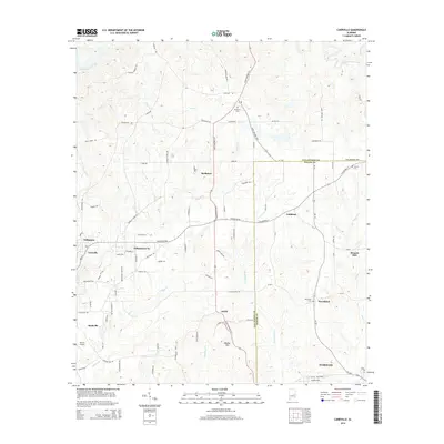
2014 Map of Carrville
USGS Topo · Published 2014About this map
Sougahatchee Creek winds across the northern reaches of this landscape where the borders of Tallapoosa and Macon Counties meet. The area is defined by a network of rural settlements and family-named landmarks, such as Baxley Hill and Broach Mill. In the western portion, the outskirts of Tallassee and the community of Carrville show a more concentrated road grid compared to the agricultural expanse surrounding Reeltown and Golddust. Genealogists and local historians can find several burial sites including Reeltown Cem, Liberty Cem, and Woodland Cem, which anchor the small communities in this part of Alabama. The map also documents the location of Reeves Airport near Buckville, alongside numerous named tributaries like Coon Cr and Wauxamaka Cr that feed into the larger creek systems of the region.
Find a feature on this map
86 named features on this map. Tap any name to fly to it.
Don’t see what you’re looking for? This feature index may not catch every label — zoom into the map to look around manually.
Map Details
Editions of this 2014 Carrville Map
This is the sole edition of this map. No revisions or reprints were ever made.
Other maps of this area

1906 · Dadeville
USGS Topo · 1:125,000

1955 · Phenix City
USGS Topo · 1:250,000

1957 · Phenix City
USGS Topo · 1:250,000

1958 · Phenix City
USGS Topo · 1:250,000

1971 · Ponders
USGS Topo · 1:24,000

1971 · Carrville
USGS Topo · 1:24,000
1971 · Tallassee
USGS Topo · 1:24,000

1971 · Tuskegee
USGS Topo · 1:24,000

1971 · Shorter
USGS Topo · 1:24,000

1971 · Thornton
USGS Topo · 1:24,000