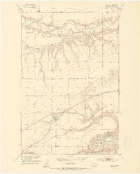
1953 Map of Carter
USGS Topo · Published 1954About this map
The town of Carter stands as a central hub in Chouteau County, positioned where the high plains break into the deep drainages of the Missouri River Basin. At this mid-century moment, the Great Northern railroad cuts a diagonal line across the prairie, anchoring the local economy to the rails and the nearby Missouri River. The landscape is defined by dramatic erosion, where significant coulees like Weatherwax Coulee, Bullhead Coulee, and Black Coulee carve through the terrain toward the Teton River in the north.
Find a feature on this map
16 named features on this map. Tap any name to fly to it.
Don’t see what you’re looking for? This feature index may not catch every label — zoom into the map to look around manually.
Map Details
Editions of this 1953 Carter Map
3 editions found
Other maps of this area

1886 · Great Falls
USGS Topo · 1:250,000

1890 · Fort Benton
USGS Topo · 1:250,000

1892 · Fort Benton
USGS Topo · 1:250,000

1897 · Fort Benton
USGS Topo · 1:250,000

1948 · Portage
USGS Topo · 1:62,500

1949 · Portage
USGS Topo · 1:62,500

1950 · Dent Bridge
USGS Topo · 1:62,500

1953 · Carter
USGS Topo · 1:24,000

1953 · Tunis
USGS Topo · 1:24,000

1954 · Great Falls
USGS Topo · 1:250,000