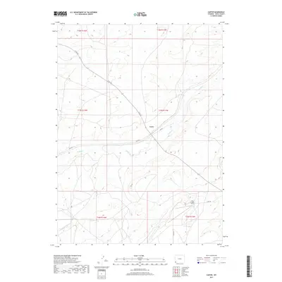
2017 Map of Carter
USGS Topo · Published 2017About this map
The settlement of Carter serves as the central point of this high-plains landscape in Uinta County, located along the winding course of Muddy Cr. This 2017 survey illustrates the sparse but structured network of rural roads such as Leroy Rd and Co Rd 225 that connect the isolated homesteads and ranch lands of southwestern Wyoming. The terrain is defined by the drainage patterns of Rock Cr and Spring Cr, which carve through the plateau towards the larger creek bed. In the southern portion of the quadrangle, the Fort Bridger Airport represents a significant modern landmark, positioned near the intersection of several county routes. The map provides a precise view of the Public Land Survey System grid, including township markers such as t17n r115w, which remain fundamental to property and genealogical research in this region.
Find a feature on this map
16 named features on this map. Tap any name to fly to it.
Don’t see what you’re looking for? This feature index may not catch every label — zoom into the map to look around manually.
Map Details
Editions of this 2017 Carter Map
This is the sole edition of this map. No revisions or reprints were ever made.
Other maps of this area

1954 · Ogden
USGS Topo · 1:250,000

1958 · Ogden
USGS Topo · 1:250,000

1960 · Ogden
USGS Topo · 1:250,000
1962 · Cumberland Gap
USGS Topo · 1:24,000
1964 · Fort Bridger
USGS Topo · 1:24,000
1964 · Carter
USGS Topo · 1:24,000
1964 · Mountain View
USGS Topo · 1:24,000
1964 · Austin Reservoir
USGS Topo · 1:24,000
1965 · Bridger
USGS Topo · 1:24,000
1965 · Leroy
USGS Topo · 1:24,000