
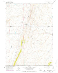
1962 Map of Cumberland Gap
USGS Topo · Published 1965About this map
Oyster Ridge dominates this high-altitude landscape along the border of Lincoln and Uinta Counties, where mid-century ranching and transit corridors follow the natural breaks in the terrain. The presence of the Union Pacific Railroad Old North Fork Grade highlights the historical importance of this pass for logistics and resource extraction, while local life centers around the Ziller Ranch and Company Ranch. Evidence of earlier settlement remains at the Cumberland Cem and the Storm Shelter Cabin No 2, situated near the eponymous Cumberland Gap. The drainage patterns of Little Muddy Creek, Albert Creek, and Whitney Creek define the navigation of the Cumberland Flats, showing a region defined by its water sources and the Carter Cutoff Road.
Find a feature on this map
17 named features on this map. Tap any name to fly to it.
Don’t see what you’re looking for? This feature index may not catch every label — zoom into the map to look around manually.
Map Details
Editions of this 1962 Cumberland Gap Map
2 editions found
Other maps of this area

1954 · Ogden
USGS Topo · 1:250,000

1958 · Ogden
USGS Topo · 1:250,000

1960 · Ogden
USGS Topo · 1:250,000

1962 · Elkol SW
USGS Topo · 1:24,000

1962 · Elkol
USGS Topo · 1:24,000

1962 · Warfield Creek
USGS Topo · 1:24,000

1964 · Carter
USGS Topo · 1:24,000

1965 · Bridger
USGS Topo · 1:24,000

1965 · Meadow Draw
USGS Topo · 1:24,000
1969 · Mulkay Spring
USGS Topo · 1:24,000