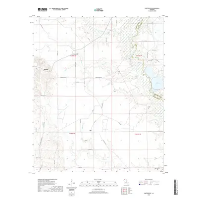
2018 Map of Carterville
USGS Topo · Published 2018About this map
Carterville and the surrounding piney woods of northern Bossier Parish define this landscape near the Arkansas border. The terrain is deeply inscribed by the winding course of Bodcau Creek, which forms the boundary with Webster Parish to the east. This water system, including the Paper Mill Pond and the secluded Goodwin Spring, has long shaped the local economy and settlement patterns. Genealogy researchers will find a significant distribution of family and community burial sites, from Timothy Cem in the northeast to Hill Cem in the southwest corner. The map also documents the transition from agriculture to industry, noted by the Mott Oilfield Rd and the small crossroads at Redland and Mot. Wooded tracts are interlaced with local thoroughfares like Walkers Chapel Rd and Dixon Cutoff Rd, providing a detailed view of the rural infrastructure in the early 21st century.
Find a feature on this map
53 named features on this map. Tap any name to fly to it.
Don’t see what you’re looking for? This feature index may not catch every label — zoom into the map to look around manually.
Map Details
Editions of this 2018 Carterville Map
This is the sole edition of this map. No revisions or reprints were ever made.
Other maps of this area

1922 · Sarepta
USGS Topo · 1:62,500

1924 · Sarepta
USGS Topo · 1:62,500

1950 · Plain Dealing SW
USGS Topo · 1:31,680

1950 · Plain Dealing NE
USGS Topo · 1:31,680

1950 · Plain Dealing SE
USGS Topo · 1:31,680

1950 · Plain Dealing NW
USGS Topo · 1:31,680

1952 · Bradley
USGS Topo · 1:24,000

1952 · Bradley SE
USGS Topo · 1:24,000

1953 · Carterville
USGS Topo · 1:24,000

1953 · El Dorado
USGS Topo · 1:250,000