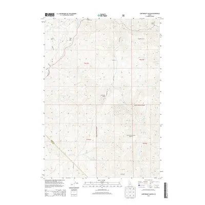
2013 Map of Cartwright Canyon
USGS Topo · Published 2013About this map
Dobson Ranch sits amidst a network of high-elevation canyons and gulches north of Boise, where the landscape transitions into the Boise National Forest. This 2013 survey illustrates a terrain defined by steep drainage systems like Cartwright Canyon and the winding course of Shafer Cr. The map captures a mix of private ranching interests and public lands, marked by distinctive geological features such as Bread Loaf Rock and the prominent Stack Rock at the southern boundary. Transportation through this part of Boise and Ada counties relies on historically significant routes including Horseshoe Bend Rd and Cartwright Rd. Remote aviation access is noted at the Loomis Airport, while numerous watercourses like Spring Valley Cr and Cottonwood Cr provide a detailed look at the local watershed before it feeds into larger valley systems.
Find a feature on this map
32 named features on this map. Tap any name to fly to it.
Don’t see what you’re looking for? This feature index may not catch every label — zoom into the map to look around manually.
Map Details
Editions of this 2013 Cartwright Canyon Map
This is the sole edition of this map. No revisions or reprints were ever made.
Other maps of this area

1892 · Boise
USGS Topo · 1:125,000

1897 · Boise
USGS Topo · 1:125,000

1949 · Robie Creek
USGS Topo · 1:24,000

1953 · Eagle
USGS Topo · 1:24,000

1953 · Montour
USGS Topo · 1:62,500

1954 · Boise North
USGS Topo · 1:24,000

1954 · Boise
USGS Topo · 1:62,500

1955 · Boise
USGS Topo · 1:250,000

1957 · Cartwright Canyon
USGS Topo · 1:24,000

1957 · Horseshoe Bend
USGS Topo · 1:24,000