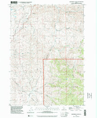
1998 Map of Cartwright Canyon
USGS Topo · Published 2002About this map
Boise National Forest occupies the southeastern corner of this quadrangle, where the terrain transitions into the high drainage basins of the Boise mountains. The landscape is defined by an intricate network of watercourses, including the central Cartwright Canyon and the winding paths of Shafer Creek and Cottonwood Creek. The presence of the Dobson Ranch and distinctive geological landmarks like Bread Loaf Rock and Stack Rock provide specific points of reference for local historians and land-use researchers.
Find a feature on this map
21 named features on this map. Tap any name to fly to it.
Don’t see what you’re looking for? This feature index may not catch every label — zoom into the map to look around manually.
Map Details
Editions of this 1998 Cartwright Canyon Map
This is the sole edition of this map. No revisions or reprints were ever made.
Other maps of this area

1892 · Boise
USGS Topo · 1:125,000

1897 · Boise
USGS Topo · 1:125,000

1949 · Robie Creek
USGS Topo · 1:24,000

1953 · Eagle
USGS Topo · 1:24,000

1953 · Montour
USGS Topo · 1:62,500

1954 · Boise North
USGS Topo · 1:24,000

1954 · Boise
USGS Topo · 1:62,500

1955 · Boise
USGS Topo · 1:250,000

1957 · Cartwright Canyon
USGS Topo · 1:24,000

1957 · Horseshoe Bend
USGS Topo · 1:24,000