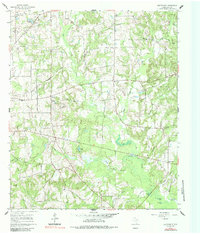
1960 Map of Cartwright
USGS Topo · Published 1985About this map
Cartwright and the surrounding rural pockets of Wood County are defined by a network of small family-named creeks and scattered community institutions in this 1960 era survey. The landscape is dotted with essential local landmarks like Lone Grove Sch, Liberty Sch, and Ebenezer Ch, reflecting a time when rural education and worship were centered near the farmsteads they served. A notable concentration of water features including Midway Lake and Chones Pond suggests a well-watered timber or agricultural district.
Find a feature on this map
39 named features on this map. Tap any name to fly to it.
Don’t see what you’re looking for? This feature index may not catch every label — zoom into the map to look around manually.
Map Details
Editions of this 1960 Cartwright Map
2 editions found
Other maps of this area

1956 · Tyler
USGS Topo · 1:250,000

1960 · Shady Grove
USGS Topo · 1:24,000

1960 · Hainesville
USGS Topo · 1:24,000

1960 · Winnsboro
USGS Topo · 1:24,000

1960 · Mineola
USGS Topo · 1:24,000

1960 · Cartwright
USGS Topo · 1:24,000

1960 · Newsome
USGS Topo · 1:24,000

1960 · Rhonesboro
USGS Topo · 1:24,000

1960 · Pleasant Grove
USGS Topo · 1:24,000

1960 · Quitman
USGS Topo · 1:24,000