
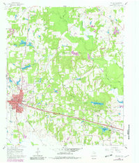
1960 Map of Mineola
USGS Topo · Published 1962About this map
The Texas and Pacific and Missouri Pacific railroads converge at Mineola, a vital transportation hub in Wood County during the early 1960s. This survey details a landscape where industrial infrastructure and rural community life coexist, marked by the presence of the Mineola Paul Oil Field and the Hoard Siding to the east. The town's social fabric is visible through institutions like the McFarland Sch and Roselawn Memorial Cem, while the surrounding countryside is dotted with numerous country churches such as Rose Hill Ch and New Hope Ch.
Find a feature on this map
44 named features on this map. Tap any name to fly to it.
Don’t see what you’re looking for? This feature index may not catch every label — zoom into the map to look around manually.
Map Details
Editions of this 1960 Mineola Map
2 editions found
Other maps of this area

1956 · Tyler
USGS Topo · 1:250,000

1959 · Calvary
USGS Topo · 1:24,000

1959 · Golden
USGS Topo · 1:24,000

1959 · Van Lake
USGS Topo · 1:24,000

1959 · Grand Saline
USGS Topo · 1:62,500

1959 · Alba
USGS Topo · 1:62,500

1960 · Hainesville
USGS Topo · 1:24,000

1960 · Lindale
USGS Topo · 1:24,000

1960 · Cartwright
USGS Topo · 1:24,000

1960 · Crow
USGS Topo · 1:24,000