
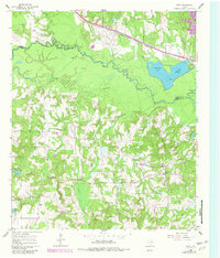
1960 Map of Crow
USGS Topo · Published 1962About this map
The Sabine River dominates this landscape, its winding course marked by an Old Sabine River Channel that indicates a shift in the river's path over time. Along the northern edge of the river, the Texas and Pacific railroad corridor connects the small settlements of Crow and Fada, while the south bank transitions into a more heavily wooded and dissected terrain. The community of Red Springs serves as a local hub south of the river, surrounded by several rural churches such as St Mary Ch and Bethesda Ch. Local industry and infrastructure are evident through a network of pipelines, a Pumping Sta, and scattered Oil Wells. For genealogists, the map preserves the locations of the Red Springs Cem and Marshall Cem, along with numerous named water bodies like Overton Lake and Brumley Lake that define the local drainage system.
Find a feature on this map
37 named features on this map. Tap any name to fly to it.
Don’t see what you’re looking for? This feature index may not catch every label — zoom into the map to look around manually.
Map Details
Editions of this 1960 Crow Map
2 editions found
Other maps of this area

1938 · Winona
USGS Topo · 1:48,000

1943 · Winona
USGS Topo · 1:62,500

1948 · Tyler
USGS Topo · 1:62,500

1949 · Tyler
USGS Topo · 1:62,500

1956 · Tyler
USGS Topo · 1:250,000

1960 · Shady Grove
USGS Topo · 1:24,000

1960 · Hawkins
USGS Topo · 1:24,000

1960 · Hainesville
USGS Topo · 1:24,000

1960 · Lindale
USGS Topo · 1:24,000

1960 · Mineola
USGS Topo · 1:24,000