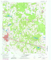
1960 Map of Mineola
USGS Topo · Published 1982About this map
The town of Mineola serves as a major hub in this Wood County landscape, defined by its position along the Missouri Pacific railroad and the convergence of local commerce during the mid-twentieth century. Educational and social life center on the High Sch and McFarland Sch, while the surrounding countryside is dotted with small rural communities like Hoard and New Hope. The area's spiritual and family history is anchored by numerous country churches and burial grounds, including Concord Ch and Roselawn Memorial Cem.
Find a feature on this map
53 named features on this map. Tap any name to fly to it.
Don’t see what you’re looking for? This feature index may not catch every label — zoom into the map to look around manually.
Map Details
Editions of this 1960 Mineola Map
2 editions found
Other maps of this area

1956 · Tyler
USGS Topo · 1:250,000

1959 · Calvary
USGS Topo · 1:24,000

1959 · Golden
USGS Topo · 1:24,000

1959 · Van Lake
USGS Topo · 1:24,000

1959 · Grand Saline
USGS Topo · 1:62,500

1959 · Alba
USGS Topo · 1:62,500

1960 · Hainesville
USGS Topo · 1:24,000

1960 · Lindale
USGS Topo · 1:24,000

1960 · Mineola
USGS Topo · 1:24,000

1960 · Cartwright
USGS Topo · 1:24,000