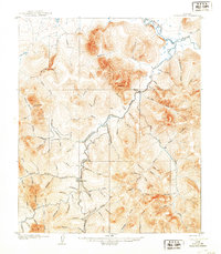
1907 Map of Casadepaga
USGS Topo · Published 1907About this map
The Council City and Solomon River Railroad snakes through this Seward Peninsula landscape, following the winding course of the Casadepaga River during the height of the region's gold rush era. A solitary Roadhouse stands near the confluence of the river and Banner Creek, serving as a critical waypoint for prospectors and travelers moving between the coast and the inland mining districts. The terrain is a complex network of drainage basins, with dozens of named waterways like Goldbottom Cr, Bonanza Creek, and Myrtle Creek etched into the slopes of Mt Dixon.
Find a feature on this map
86 named features on this map. Tap any name to fly to it.
Don’t see what you’re looking for? This feature index may not catch every label — zoom into the map to look around manually.
Map Details
Editions of this 1907 Casadepaga Map
2 editions found
Other maps of this area

1907 · Casadepaga
USGS Topo · 1:62,500

1907 · Solomon
USGS Topo · 1:62,500

1950 · Bendeleben A-6
USGS Topo · 1:63,360

1950 · Bendeleben A-4
USGS Topo · 1:63,360

1950 · Bendeleben A-5
USGS Topo · 1:63,360

1950 · Solomon C-5
USGS Topo · 1:63,360

1950 · Solomon C-6
USGS Topo · 1:63,360

1950 · Solomon C-4
USGS Topo · 1:63,360

1950 · Bendeleben
USGS Topo · 1:250,000

1950 · Solomon
USGS Topo · 1:250,000