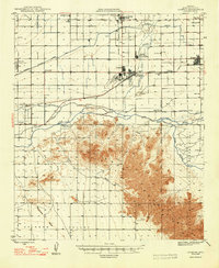
1948 Map of Cashion
USGS Topo · Published 1948About this map
The Sierra Estrella mountains dominate the southern portion of this 1940s landscape, providing a stark contrast to the burgeoning agricultural and military developments to the north. This postwar era reveals a region defined by extensive irrigation networks, including the Roosevelt Irrigation District Canal, which fueled the growth of farming settlements like Cashion and Tolleson. The map documents a significant military presence following World War II, showing the U S Naval Air Facility and Goodyear Landing Field near the settlement of Goodyear. Rural life is anchored by local institutions such as Pendergast Sch and the Agua Fria Sch, while the Avondale Farm Labor Supply Center highlights the organized agricultural labor systems of the day. The confluence of the Agua Fria River and the Gila River serves as a geographic centerpiece, marking the boundary of the Gila River Indian Reservation in the southeast.
Find a feature on this map
34 named features on this map. Tap any name to fly to it.
Don’t see what you’re looking for? This feature index may not catch every label — zoom into the map to look around manually.
Map Details
Editions of this 1948 Cashion Map
2 editions found
Other maps of this area

1912 · Phoenix
USGS Topo · 1:62,500

1913 · Maricopa
USGS Topo · 1:62,500

1914 · Phoenix
USGS Topo · 1:62,500

1915 · Maricopa
USGS Topo · 1:62,500

1946 · Avondale
USGS Topo · 1:62,500

1948 · Cashion
USGS Topo · 1:62,500

1951 · Mobile
USGS Topo · 1:62,500

1951 · Cotton Center
USGS Topo · 1:62,500

1952 · Laveen
USGS Topo · 1:24,000

1952 · Montezuma Peak
USGS Topo · 1:24,000