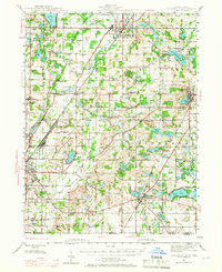
1945 Map of Cassopolis
USGS Topo · Published 1967About this map
Dowagiac and Cassopolis anchor this mid-1940s landscape, a region defined by an intricate network of rural schools and small-town commerce just before post-war expansion transformed the Great Lakes region. The map reveals a dense social infrastructure, with namesake educational landmarks like the Electric Light Sch near Niles and the Hardscrabble Sch in the north. The presence of the New York Central and Pennsylvania railroads highlights the era's reliance on rail for transporting local agricultural goods. In the southern reaches, Edwardsburg sits near a cluster of glacial lakes including Eagle Lake and Pleasant Lake, while the Dowagiac River winds through the western townships. Genealogists will find significant value in the distribution of family-named landmarks and cemeteries, such as the Winkler Cem and Barron Lake Cem, which speak to the deep-rooted settlement patterns of Cass County.
Find a feature on this map
98 named features on this map. Tap any name to fly to it.
Don’t see what you’re looking for? This feature index may not catch every label — zoom into the map to look around manually.
Map Details
Editions of this 1945 Cassopolis Map
3 editions found
Other maps of this area

1927 · Niles
USGS Topo · 1:62,500

1927 · Hartford
USGS Topo · 1:62,500

1927 · Benton Harbor
USGS Topo · 1:62,500

1930 · Benton Harbor
USGS Topo · 1:62,500

1930 · Niles
USGS Topo · 1:62,500

1931 · Hartford
USGS Topo · 1:62,500

1943 · Niles
USGS Topo · 1:62,500

1944 · Marcellus
USGS Topo · 1:62,500

1945 · Cassopolis
USGS Topo · 1:62,500

1946 · Marcellus
USGS Topo · 1:62,500