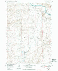
1948 Map of Castle Butte
USGS Topo · Published 1985About this map
The Emigrant Trail traverses the northern reaches of this Owyhee County landscape, tracing a historical path above the Snake River. This 1940s topography captures a remote ranching and irrigation environment where water management is central to the local geography. Significant infrastructure such as the Log Dam, various flumes, and Artesian Wells support life across the Henderson Flats. Small-scale settlements and family-named locations like Morgan Place, Feeny Wells, and the Castle Creek Sch reflect the sparse, community-centered population of the era.
Find a feature on this map
27 named features on this map. Tap any name to fly to it.
Don’t see what you’re looking for? This feature index may not catch every label — zoom into the map to look around manually.
Map Details
Editions of this 1948 Castle Butte Map
2 editions found
Other maps of this area

1892 · Bisuka
USGS Topo · 1:125,000

1894 · Bisuka
USGS Topo · 1:125,000

1947 · Grand View
USGS Topo · 1:62,500

1947 · Jackass Butte
USGS Topo · 1:24,000

1947 · Wild Horse Butte
USGS Topo · 1:24,000

1947 · Vinson Wash
USGS Topo · 1:24,000

1948 · Castle Butte
USGS Topo · 1:24,000

1948 · Vinson Wash
USGS Topo · 1:24,000

1948 · Big Foot Butte
USGS Topo · 1:24,000

1948 · Wild Horse Butte
USGS Topo · 1:24,000