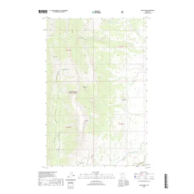
2020 Map of Castle Reef
USGS Topo · Published 2020About this map
Lewis & Clark National Forest dominates this landscape along the eastern front of the Rocky Mountains, where the high peaks of the Sawtooth Range meet the plains. The terrain is defined by a series of dramatic vertical features, most notably the prominent crest of Castle Reef and the high summit of Grass Hill. These ridges are carved by a dense network of drainages, including Hannan Gulch and Rierdon Gulch, which channel water toward the lower elevations. At the mountain front, the natural hydrology is adapted for regional use via the Pishkun Canal, which skirts the edge of the Alkali Flat. This area illustrates the sharp transition from protected wilderness to the managed water systems of the Sun River valley, providing a clear record of the boundary between the rugged mountain interior and the settled agricultural fringe of Teton County.
Find a feature on this map
27 named features on this map. Tap any name to fly to it.
Don’t see what you’re looking for? This feature index may not catch every label — zoom into the map to look around manually.
Map Details
Editions of this 2020 Castle Reef Map
This is the sole edition of this map. No revisions or reprints were ever made.
Other maps of this area

1903 · Saypo
USGS Topo · 1:125,000

1955 · Choteau
USGS Topo · 1:250,000

1957 · Choteau
USGS Topo · 1:250,000

1958 · Choteau
USGS Topo · 1:250,000

1958 · Ear Mountain
USGS Topo · 1:24,000

1958 · Lake Theboe
USGS Topo · 1:24,000

1958 · Our Lake
USGS Topo · 1:24,000

1958 · Barr Creek
USGS Topo · 1:24,000

1958 · Sawtooth Ridge
USGS Topo · 1:24,000

1958 · Patricks Basin
USGS Topo · 1:24,000