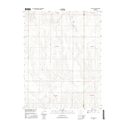
2015 Map of Castle Rock
USGS Topo · Published 2015About this map
Castle Rock stands as the defining geological landmark in this part of western Kansas, where the chalk spires of the Smoky Hill River valley have long served as a beacon for travelers. This 2015 U.S. Geological Survey representation of the high plains landscape captures the intricate drainage patterns of the Hackberry Cr and Big Windy Cr systems, which have carved through the soft sedimentary layers over millennia. The map details the transition from the Gove County uplands down toward the river's path, tracing the course of Sand Cr and the rural network of Castle Rock Rd and other county routes that follow the section lines of the Public Land Survey System. The boundary between Gove and Trego counties runs north to south, marking a administrative divide in this sparsely settled region of the central plains.
Find a feature on this map
25 named features on this map. Tap any name to fly to it.
Don’t see what you’re looking for? This feature index may not catch every label — zoom into the map to look around manually.
Map Details
Editions of this 2015 Castle Rock Map
This is the sole edition of this map. No revisions or reprints were ever made.
Other maps of this area

1955 · Scott City
USGS Topo · 1:250,000

1958 · Scott City
USGS Topo · 1:250,000

1972 · Gove NE
USGS Topo · 1:24,000

1972 · Castle Rock NW
USGS Topo · 1:24,000
1972 · Castle Rock NE
USGS Topo · 1:24,000

1974 · Gove SE
USGS Topo · 1:24,000

1974 · Castle Rock
USGS Topo · 1:24,000
1974 · Gibson Creek
USGS Topo · 1:24,000

1974 · Pendennis
USGS Topo · 1:24,000
1981 · Arnold
USGS Topo · 1:24,000