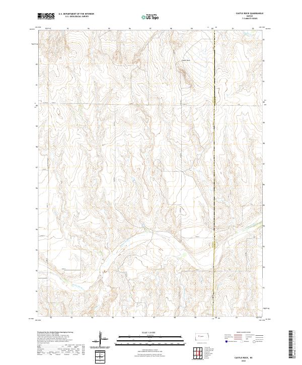
2022 Map of Castle Rock
USGS Topo · Published 2022About this map
Castle Rock stands as the primary landmark of this High Plains landscape, situated along the northern reaches of the Smoky Hill River valley. This 2022 survey captures the expansive rural character of eastern Gove County, where the topography is defined by the erosion-carved breaks and drainage systems of Big Windy Cr, Sand Cr, and Hackberry Cr. The map details the precise section lines and range divisions of the Public Land Survey System, including t14s r26w and its neighboring townships, which dictate the modern grid of local connectors like Castle Rock Rd and 120 Ave. The land use pattern reflects the high-plains agriculture and ranching heritage of western Kansas, where most movement is confined to the gravel county roads that border the vast, open sections of the Gove Co and Trego Co line.
Find a feature on this map
28 named features on this map. Tap any name to fly to it.
Don’t see what you’re looking for? This feature index may not catch every label — zoom into the map to look around manually.
Map Details
Editions of this 2022 Castle Rock Map
This is the sole edition of this map. No revisions or reprints were ever made.
Other maps of this area

1955 · Scott City
USGS Topo · 1:250,000

1958 · Scott City
USGS Topo · 1:250,000

1972 · Gove NE
USGS Topo · 1:24,000

1972 · Castle Rock NW
USGS Topo · 1:24,000
1972 · Castle Rock NE
USGS Topo · 1:24,000

1974 · Gove SE
USGS Topo · 1:24,000

1974 · Castle Rock
USGS Topo · 1:24,000
1974 · Gibson Creek
USGS Topo · 1:24,000

1974 · Pendennis
USGS Topo · 1:24,000
1981 · Arnold
USGS Topo · 1:24,000