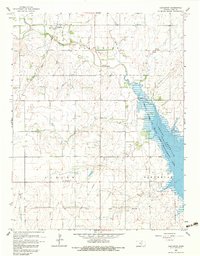
1965 Map of Castleton
USGS Topo · Published 1983About this map
Castleton serves as the primary settlement in this section of Reno County, situated at the intersection of the Atchison Topeka and Santa Fe railroad and the North Fork of the Ninnescah River. The landscape is defined by the transition between agrarian plains and the emerging waters of the Cheney Reservoir, which dominates the eastern half of the map. This reservoir, surrounded by the Cheney Reservoir State Game Management Area, represents a major mid-century transformation of the local geography.
Find a feature on this map
21 named features on this map. Tap any name to fly to it.
Don’t see what you’re looking for? This feature index may not catch every label — zoom into the map to look around manually.
Map Details
Editions of this 1965 Castleton Map
2 editions found
Other maps of this area

1889 · Cheney
USGS Topo · 1:125,000

1891 · Cheney
USGS Topo · 1:125,000

1892 · Kingman
USGS Topo · 1:125,000

1894 · Kingman
USGS Topo · 1:125,000

1901 · Cheney
USGS Topo · 1:125,000

1955 · Wichita
USGS Topo · 1:250,000

1955 · Pratt
USGS Topo · 1:250,000

1958 · Wichita
USGS Topo · 1:250,000

1959 · Pratt
USGS Topo · 1:250,000
1961 · Haven
USGS Topo · 1:24,000