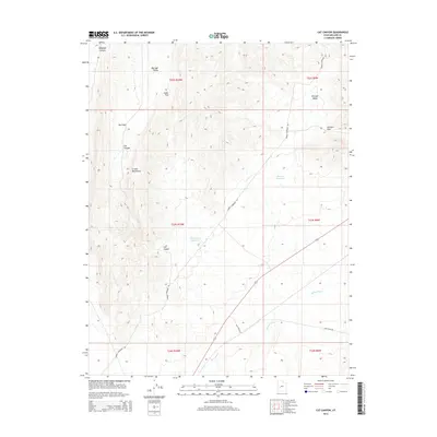
2014 Map of Cat Canyon
USGS Topo · Published 2014About this map
Cricket Mountains dominate the western terrain of this 2014 survey in Millard County, characterized by a series of high ridges and narrow passes. The landscape is defined by its drainage and water management, with Georges Reservoir and Cat Canyon Reservoir serving as critical points in an arid environment. The Beaver River winds through the southeastern portion of the quadrangle, illustrating the natural watercourses that have shaped regional land use. Modern infrastructure is represented by the Energy Corridor Rd, which transects the valley floors. Several named gaps, including Cedar Pass, Red Pass, and Georges Pass, indicate the traditional routes used to navigate between the high country and the broader basins of Big Sage Valley and Georges Valley.
Find a feature on this map
19 named features on this map. Tap any name to fly to it.
Don’t see what you’re looking for? This feature index may not catch every label — zoom into the map to look around manually.
Map Details
Editions of this 2014 Cat Canyon Map
This is the sole edition of this map. No revisions or reprints were ever made.
Other maps of this area

1885 · Beaver
USGS Topo · 1:250,000

1953 · Richfield
USGS Topo · 1:250,000

1958 · Richfield
USGS Topo · 1:250,000

1960 · Beaver Lake Mts.
USGS Topo · 1:62,500

1972 · Headlight Mtn
USGS Topo · 1:24,000
1972 · Sevier Lake NE
USGS Topo · 1:24,000

1973 · Cruz
USGS Topo · 1:24,000

1973 · Antelope Spring
USGS Topo · 1:24,000
1973 · Borden
USGS Topo · 1:24,000

1973 · Black Rock
USGS Topo · 1:24,000