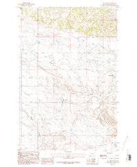
1986 Map of Cat Creek
USGS Topo · Published 1986About this map
Cat Creek serves as the focal point for this landscape in central Montana, where the terrain is defined by a dense network of coulees and intermittent watercourses. The 1986 edition illustrates a region shaped by natural drainage patterns, with Jackson Coulee and Long Coulee cutting through the northern reaches of the quadrangle. As a provisional release based on field data from the late 1970s, the map provides a look at the rural infrastructure of Petroleum County, showing the proximity of the Cat Creek settlement to the winding banks of its namesake stream. Small-scale industrial activity is evidenced by a Gravel Pit, while the surrounding land is crossed by Bull Springs Coulee and Gorman Coulee, suggesting a landscape primarily dedicated to ranching and resource extraction.
Find a feature on this map
7 named features on this map. Tap any name to fly to it.
Don’t see what you’re looking for? This feature index may not catch every label — zoom into the map to look around manually.
Map Details
Editions of this 1986 Cat Creek Map
2 editions found
Other maps of this area

1954 · Jordan
USGS Topo · 1:250,000

1954 · Forsyth
USGS Topo · 1:250,000

1954 · Roundup
USGS Topo · 1:250,000

1954 · Lewistown
USGS Topo · 1:250,000

1956 · Jordan
USGS Topo · 1:250,000

1957 · Forsyth
USGS Topo · 1:250,000

1958 · Jordan
USGS Topo · 1:250,000

1958 · Roundup
USGS Topo · 1:250,000

1958 · Forsyth
USGS Topo · 1:250,000

1959 · Lewistown
USGS Topo · 1:250,000