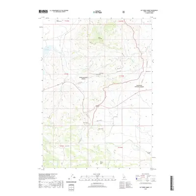
2020 Map of Cat Creek Summit
USGS Topo · Published 2020About this map
Cat Creek Summit marks a high point in this Idaho landscape where the high plateau of Little Camas Prairie meets the volcanic slopes of the Mount Bennett Hills. This 2020 survey records a transition between two major federal reserves, with the Boise National Forest occupying the northern reaches and the Sawtooth National Forest to the east. The terrain is defined by prominent basalt features such as Skull Rock and the Castle Rocks, reflecting the geologic history of the Snake River Plain's northern edge. Human activity is concentrated along the corridor of Old Hwy 68 and near the Little Camas Reservoir, while the remote S Bar Ranch Airport serves as a lone outpost in the southeastern quadrant near the Camas Creek drainage. The map's drainage network, including the Malad River and Cat Creek, illustrates the complex hydrology of this high-elevation ranching and forest land.
Find a feature on this map
40 named features on this map. Tap any name to fly to it.
Don’t see what you’re looking for? This feature index may not catch every label — zoom into the map to look around manually.
Map Details
Editions of this 2020 Cat Creek Summit Map
This is the sole edition of this map. No revisions or reprints were ever made.
Other maps of this area

1892 · Camas Prairie
USGS Topo · 1:125,000

1893 · Camas Prairie
USGS Topo · 1:125,000

1955 · Hailey
USGS Topo · 1:250,000
1958 · Bennett Mtn
USGS Topo · 1:62,500

1958 · King Hill
USGS Topo · 1:62,500

1959 · Hailey
USGS Topo · 1:250,000

1962 · Hailey
USGS Topo · 1:250,000

1963 · High Prairie
USGS Topo · 1:24,000
1963 · Sprout Mtn
USGS Topo · 1:24,000
1973 · House Mountain
USGS Topo · 1:24,000