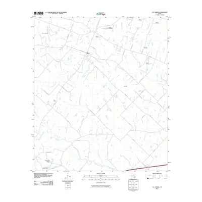
2010 Map of Cat Spring
USGS Topo · Published 2010About this map
Cat Spring serves as the central hub of this Austin County landscape, where the agricultural traditions of the Texas coastal plain are etched into the drainage patterns of the San Bernard River. The area is defined by a dense network of farm-to-market roads and family-named routes such as Newberg Rd and Schmoeller Sens Rd, which connect scattered homesteads and local landmarks. Genealogists will find significant value in the distribution of family and community burial sites, including the Schlopata Cemetery, Jokse Cemetery, and Swearingen Cemetery, each marking the settlement history of the region. The terrain is relatively low-lying, characterized by numerous small tributaries like Cat Spring Creek, Little Bernard Creek, and Crooked Branch. Notable water management features such as Hillbolt Lake Dam and Conner Lake Dam appear alongside localized elevations like Red Hill, illustrating how the community has adapted to the seasonal hydrology of the river basin.
Find a feature on this map
53 named features on this map. Tap any name to fly to it.
Don’t see what you’re looking for? This feature index may not catch every label — zoom into the map to look around manually.
Map Details
Editions of this 2010 Cat Spring Map
This is the sole edition of this map. No revisions or reprints were ever made.
Other maps of this area

1953 · Seguin
USGS Topo · 1:250,000

1956 · Bellville
USGS Topo · 1:62,500

1956 · Sealy
USGS Topo · 1:62,500

1956 · Wallis
USGS Topo · 1:62,500

1957 · Eagle Lake
USGS Topo · 1:62,500

1958 · Seguin
USGS Topo · 1:250,000

1958 · Bernardo
USGS Topo · 1:24,000

1958 · Alleyton
USGS Topo · 1:24,000
1960 · Rexville
USGS Topo · 1:24,000
1960 · Sealy
USGS Topo · 1:24,000