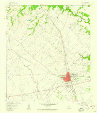
1960 Map of Sealy
USGS Topo · Published 1961About this map
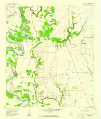
Sealy stands as a busy rail hub in the early 1960s, defined by the crossing of the Missouri Kansas Texas and the Gulf Colorado And Santa Fe lines. This intersection drove the growth of the town, visible here with its Hospital, Athletic Field, and organized grid. Beyond the town limits, the landscape transitions into a network of small agricultural settlements and family-named landmarks. To the northeast, the Macedonia Ch and Macedonia Cem anchor a rural community, while to the northwest, Millheim and Peters mark established locales along the drainages of Clear Creek and Deadman Creek. The map also captures an Old Railroad Grade and numerous pipelines, illustrating the evolution of transport and energy infrastructure through Austin County. Water features like Peters Lake and Bullinger Creek provide natural boundaries for the surrounding field lines and pastures.
Find a feature on this map
32 named features on this map. Tap any name to fly to it.
Don’t see what you’re looking for? This feature index may not catch every label — zoom into the map to look around manually.
Map Details
Editions of this 1960 Sealy Map
Other maps of this area

1953 · Seguin
USGS Topo · 1:250,000

1956 · Bellville
USGS Topo · 1:62,500

1956 · Sealy
USGS Topo · 1:62,500

1956 · Wallis
USGS Topo · 1:62,500

1957 · Eagle Lake
USGS Topo · 1:62,500

1958 · Seguin
USGS Topo · 1:250,000

1960 · Wallis
USGS Topo · 1:24,000

1960 · San Felipe
USGS Topo · 1:24,000
1960 · Rexville
USGS Topo · 1:24,000
1960 · Sunny Side
USGS Topo · 1:24,000