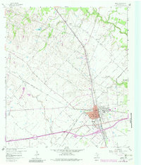
1960 Map of Sealy
USGS Topo · Published 1982About this map
The town of Sealy stands at the convergence of three major rail lines in this 1960 survey, serving as a vital transportation hub for Austin County. The Gulf Colorado and Santa Fe, Missouri Kansas Texas, and Atchison Topeka and Santa Fe railroads crisscross the landscape, illustrating the region's historical dependence on rail transit for agricultural and industrial goods. Beyond the urban center, the map reveals the small settlements of Peters and Macedonia, the latter of which is anchored by the Macedonia Cem. To the east, the edge of San Felipe appears near the banks of Bullinger Creek. The terrain is characterized by a network of waterways like Little Bernard Creek and Mill Creek, interspersed with Gravel Pits and Gas Well sites that point to the area's resource-based economy during the mid-century era.
Find a feature on this map
35 named features on this map. Tap any name to fly to it.
Don’t see what you’re looking for? This feature index may not catch every label — zoom into the map to look around manually.
Map Details
Editions of this 1960 Sealy Map
Other maps of this area

1953 · Seguin
USGS Topo · 1:250,000

1956 · Bellville
USGS Topo · 1:62,500

1956 · Sealy
USGS Topo · 1:62,500

1956 · Wallis
USGS Topo · 1:62,500

1957 · Eagle Lake
USGS Topo · 1:62,500

1958 · Seguin
USGS Topo · 1:250,000

1960 · Wallis
USGS Topo · 1:24,000

1960 · San Felipe
USGS Topo · 1:24,000
1960 · Rexville
USGS Topo · 1:24,000
1960 · Sealy
USGS Topo · 1:24,000