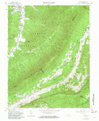
1963 Map of Catawba
USGS Topo · Published 1965About this map
New Castle and Catawba anchor this mid-century survey of the Appalachian landscape where Craig, Botetourt, and Roanoke counties meet. The valley terrain is defined by the winding course of Catawba Creek and Craig Creek, while the ridges of North Mountain and Gravelly Ridge dominate the center of the sheet. A significant portion of the area is protected within the Jefferson National Forest, which is traversed by the Appalachian Trail as it crosses McAfee Knob.
Find a feature on this map
34 named features on this map. Tap any name to fly to it.
Don’t see what you’re looking for? This feature index may not catch every label — zoom into the map to look around manually.
Map Details
Editions of this 1963 Catawba Map
4 editions found
Other maps of this area

1887 · Lewisburg
USGS Topo · 1:125,000

1890 · Roanoke
USGS Topo · 1:125,000

1890 · Christiansburg
USGS Topo · 1:125,000

1891 · Roanoke
USGS Topo · 1:125,000

1891 · Lewisburg
USGS Topo · 1:125,000

1894 · Natural Bridge
USGS Topo · 1:125,000

1913 · Eagle Rock
USGS Topo · 1:48,000

1915 · Eagle Rock
USGS Topo · 1:62,500

1929 · Roanoke
USGS Topo · 1:48,000

1929 · Salem
USGS Topo · 1:48,000