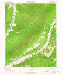
1963 Map of Catawba
USGS Topo · Published 1981About this map
Catawba Mountain and North Mountain dominate this early 1960s study of the Virginia highlands, where narrow valleys support long-established settlements and institutional grounds. The Catawba Sanatorium sits near the base of the ridge, a significant local landmark alongside the Sewage Disposal and Pumping Sta facilities. Rural life is anchored by family-named sites such as Morgan Cem and congregations like Mountain View Ch and Catawba Valley Ch.
Find a feature on this map
42 named features on this map. Tap any name to fly to it.
Don’t see what you’re looking for? This feature index may not catch every label — zoom into the map to look around manually.
Map Details
Editions of this 1963 Catawba Map
4 editions found
Other maps of this area

1887 · Lewisburg
USGS Topo · 1:125,000

1890 · Roanoke
USGS Topo · 1:125,000

1890 · Christiansburg
USGS Topo · 1:125,000

1891 · Roanoke
USGS Topo · 1:125,000

1891 · Lewisburg
USGS Topo · 1:125,000

1894 · Natural Bridge
USGS Topo · 1:125,000

1913 · Eagle Rock
USGS Topo · 1:48,000

1915 · Eagle Rock
USGS Topo · 1:62,500

1929 · Roanoke
USGS Topo · 1:48,000

1929 · Salem
USGS Topo · 1:48,000