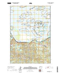
2020 Map of Cathlamet Bay
USGS Topo · Published 2020About this map
Cathlamet Bay dominates this coastal landscape, where the Columbia River disperses into a complex network of islands and channels. The town of Astoria sits at the western edge, overlooking the John Day Channel and Tongue Point. Inland, the terrain transitions into a grid of rural roads and small settlements like Fern Hill and Svensen. The waterway is defined by numerous named landmasses such as Grassy Island, Russian Island, and Miller Sands, which are separated by a maze of passages including the North and South Channel. Local history is preserved at the Svensen Pioneer Cemetery near Svensen Junction, while the southern reaches are drained by the Wallooskee River and its tributaries. The proximity of Karpens Airport and various island roads like Svensen Island Road illustrates the modern connectivity required to navigate this amphibious geography.
Find a feature on this map
84 named features on this map. Tap any name to fly to it.
Don’t see what you’re looking for? This feature index may not catch every label — zoom into the map to look around manually.
Map Details
Editions of this 2020 Cathlamet Bay Map
This is the sole edition of this map. No revisions or reprints were ever made.
Other maps of this area
1919 · Astoria
USGS Topo · 1:62,500
1938 · Fort Columbia
USGS Topo · 1:62,500
1939 · Astoria
USGS Topo · 1:62,500
1940 · Svensen
USGS Topo · 1:62,500
1940 · Brookfield
USGS Topo · 1:62,500
1943 · Fort Columbia
USGS Topo · 1:62,500
1949 · Astoria
USGS Topo · 1:24,000
1949 · Knappton
USGS Topo · 1:24,000
1949 · Cathlamet Bay
USGS Topo · 1:24,000
1949 · Green Mountain
USGS Topo · 1:24,000