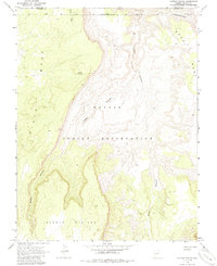
1970 Map of Cattle Canyon
USGS Topo · Published 1985About this map
The Navajo Indian Reservation landscape is defined by the dramatic meeting of high mesas and deep drainage systems in this 1970 field-checked study. The geography is dominated by the massive landforms of Piute Mesa to the west and Noka Mesa to the east, separated by the intricate branching of Cattle Canyon and Nokai Canyon. This high-desert terrain on the Shonto Plateau shows very limited human infrastructure, focusing instead on natural water sources like Fullers Spring and the drainage of Neskahi Wash. Located along the border of Utah and Arizona, the map provides a precise look at the geological features and elevations near Begashinitani before modern development or road expansion reached this section of the reservation.
Find a feature on this map
11 named features on this map. Tap any name to fly to it.
Don’t see what you’re looking for? This feature index may not catch every label — zoom into the map to look around manually.
Map Details
Editions of this 1970 Cattle Canyon Map
4 editions found
Other maps of this area

1883 · Marsh Pass
USGS Topo · 1:250,000

1886 · Henry Mountains
USGS Topo · 1:250,000

1892 · Marsh Pass
USGS Topo · 1:250,000

1892 · Henry Mountains
USGS Topo · 1:250,000

1952 · Shato Spring 1 NE
USGS Topo · 1:24,000

1952 · Agathla Peak 2 SW
USGS Topo · 1:24,000

1952 · Agathla Peak 2 NW
USGS Topo · 1:24,000

1952 · Boot Mesa
USGS Topo · 1:62,500

1952 · Clay Hills 3 SW
USGS Topo · 1:24,000

1952 · Navajo Mtn. 4 SE
USGS Topo · 1:24,000